Redesign of South East Street Still in Flux
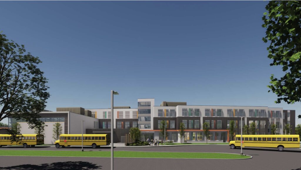
Architect's rendering of the new Fort River Elementary School. South drop off. Photo: amherstma.gov
Report on the Meeting of the Town Services and Outreach Committee, January 9, 2025
This meeting was held over Zoom and was recorded.
Present
Andy Steinberg (Chair, at-large), Hala Lord and George Ryan (District 3), Jennifer Taub (District 4), and Bob Hegner (District 5)
Staff: Paul Bockelman (Town Manager) and Guilford Mooring (Superintendent of Public Works)
Construction on South East Street Will Not Be Finished When the New School Opens
Town Manager Paul Bockelman acknowledged that, even if a design for the short stretch of South East Street between Route 9 and Main Street were agreed upon now, the project could not be completed before the September 2026 anticipated opening of the new elementary school. He said that procuring funds for design and construction and doing the work would probably take at least two years.
With that knowledge, and the fact that that the proposed design by CDM Smith Engineering, which included four roundabouts, received negative comments from the Town Services and Outreach (TSO) committee, the Transportation Advisory Committee (TAC), and the Disability Access Advisory Committee (DAAC), Chair Andy Steinberg (at large) suggested that the town see how traffic is operating when the school opens to learn if there are problems and if so, where and when. TSO member Jen Taub (District 4) agreed, saying that the hypothetical increase in traffic might not be as significant as anticipated, especially if children are encouraged to take the school busses instead of being driven in private cars.
Superintendent of Public Works Guilford Mooring said waiting would delay the project, but Bockelman noted that, during construction of the school, all traffic, both cars and buses, must enter via the north driveway. When construction is completed, however, the school buses will use the south driveway, so congestion at the north driveway may decrease.
Mooring said that allowing the redesign to use some of the land on the East Common affords the opportunity to create other plans, such as adding a slip lane along South East Street. He also mentioned an elongated (peanut) roundabout that could encompass the north driveway , as well as the intersections of Main Street, South East Street, and Old South East Street. He felt having two stop lights close together (at the north school driveway and Main Street) would be confusing and dangerous, but said he would be willing to look at it again. There is a flashing yellow light at the school now. When he was asked how that is working, Mooring said that the DPW has not paid a lot of attention to it because it was thought to be a temporary solution.
Taub said she would also like further consideration of making South East Street one-way going north and Old South East Street one-way going south, but Mooring felt that would increase traffic near the school by requiring drivers to go south almost to Route 9 and then north to the school. Bockelman also pointed out that using part of the common would likely involve removing several mature trees. The four-roundabout plan preserved the common.
George Ryan (District 3) wanted a plan to take into account the two new housing developments being built near the school (at the East Street school and at 80 Belchertown Road). Taub hoped that pedestrians from Belchertown Road would be able to walk to the school along a path near the Fort River community gardens instead of using the road; that would involve constructing a pedestrian bridge over the stream behind the school, which would be a separate project that would need to be coordinated with the Conservation Commission and Way Finders, the builders of the Belchertown Road project. There is already a path from Main Street to the school that obviates the need for pedestrians to cross driveways and the school parking lot, but Mooring noted that path is currently not well maintained and is poorly lit.
Bob Hegner (District 5) was in favor of waiting until the school opens to get information about traffic, but acknowledged that the council does not have the expertise of the DPW regarding traffic design. Bockelman pointed out that doing a five-year traffic study when the school opens would delay redesign for seven years, but Taub pointed out that the study could be much shorter. Steinberg asked about traffic conditions at the busiest times now. Hala Lord (District 3) thought that the impact of the larger school might not be as great as anticipated because people not going to the school will avoid South East Street during the busiest hours. .
However, Ryan was displeased with the idea of waiting until after the school opens to develop a plan. He said, “We’re looking at an initial period where the existing conditions are what we’re going to have to deal with, getting people in and out of that school while it’s running, and then there’ll be a period of, I don’t know, six months of construction that’ll be going on, while people are using that school. This sounds terrifying to me.”
Mooring suggested that the town request preliminary designs, one involving an added lane along South East Street and another with a peanut roundabout at Main Street to see how much of the common would be lost. He estimated that the preliminary designs would cost about $100,000 to $200,000, with a final design costing an additional $300,000. TSO members asked that proposed designs be shared with TAC and DAAC, especially considering the DAAC’s concerns about the safety of roundabouts for pedestrians, especially children and those with impaired vision or mobility. Steinberg presented a summary of the discussions at the January 13 council meeting.
TSO Solicits Input from Northampton for Proposed Transportation and Parking Commission
Bockelman’s suggestion that the town create a Transportation and Parking Commission (TPC) that could handle most decisions about traffic and parking without the involvement of the Town Council met with a favorable reception from TSO and TAC. Bockelman said his goal for the commission is to eliminate some bureaucracy. Hegner wanted the council to retain control over complex decisions, such as the one involving a redesign of the section of South East Street near the Fort River school.
Ryan developed a draft template for how the TPC would function. Northampton has an 11-member TPC, and Steinberg suggested inviting Northampton City Councilor and President Alex Jarrett to a future meeting to discuss its scope and process. Jarrett also wanted Northampton DPW Director Donna LaScaleia to attend the TSO meeting. The Northampton commission includes LaScaleia, the Chief of Police, the Parking Enforcement Administrator, the Planning Director, two city councilors, and five residents. The proposed Amherst TPC would have five members, and would not include councilors. The members would be the Superintendent of Public Works or his designee, the Chief of Police or his designee, and three members of the public with expertise or background in transportation appointed by the Town Manager. There would also be a liaison from the Planning staff.
TSO members agreed to invite the Northampton commission members to a future TSO meeting to discuss how their TPC functions. Steinberg will arrange for Jarrett and LaScaleia to attend a future meeting.
TSO Praised by TAC Chair
Realizing that the composition of TSO may change with the new year, TAC Chair Tracy Zafian praised the current members during the public comment period. She noted that TSO led the council to pass the 25mph statutory speed limit, school zones near the middle school and high school, and a safety zone near the Cushman Scott Children’s Center in North Amherst, ideas that have been talked about for a long time. She also appreciated TSO consulting with TAC on many issues.
While a polite way to do this might be in accord with this language
…especially if children are encouraged to take the school busses instead of being driven in private cars
is there any reason — with reasonable accessibility or emergency exceptions — for the language not to be
…especially if children are required to take the school busses (or walk, or ride their bikes or scooters, or take PVTA busses…) instead of being driven in private cars
instead?
Several decades ago, this was a very common practice….
You can not require kids to take the bus, as it is state law only requires buses for kids 2+ miles away. Rainy and cold days generate the worst traffic to avoid standing outside and there is no way that is getting enforced with little kids. There are some other big sources for morning traffic, e.g. UMass. This road needs to work well, or something a little more drastic needs to happen like PVTA satellite lots.
Logically and legally, it seems a little more complicated….
These laws and policies relevant to public schools providing transportation for their students
• Amherst: https://arps.org/transportation/
• Boston: https://www.bostonpublicschools.org/bps-departments/transportation/students-families/eligibility
• Mass: https://malegislature.gov/Laws/GeneralLaws/PartI/TitleXII/Chapter71/section68
specify various distances ranging from 1 to 1.5 to 2 (or more) miles between home and school, yet they are silent on allowing or restricting private car access to public school sites to drop off and pick up students: it’s unclear what is “required” or “allowed” or “discouraged” or “forbidden” with regard to such access.
But I agree with Christopher Lloyd that it’s worth exploring the spectrum of transportation alternatives —as well as incentives to adopt or eschew them — and note that his idea of PVTA satellite lots was looked into 3 decades ago and may be well worth revisiting today!
Regarding taking the bus –There are many students at FR (and elsewhere) that are enrolled in School Choice, and either not live in Amherst or are outside the FR district, which means that for the most part, a caregiver must drive them to school. But agree, that to reduce congestion and emissions it would be ideal to have greater ridership.
Yes, Michelle, that’s exactly an example of “accommodation exception” I had in mind. During our first few years in Amherst, we rented a house from a colleague in “deep south Amherst” but were looking to purchase a small house within walking distance to UMass, so requested open-enrollment for our son at Marks Meadow. He and I typically rode the Bay Road PVTA bus and then walked together the last half mile or so, though there were a few occasions where driving (and then parking for the day) was necessary. I’ve never had a UMass parking permit, but long ago (as a Marks Meadow parent) one could purchase a permit from the Immanuel Lutheran Church to park in their lot next door to Marks Meadow. And when we eventually moved about a mile northeast of Marks Meadow, we biked or walked (or skied, or slogged, depending on the weather 😉 ) together to school and work along an old farm path/road that now serves the UMass Agricultural Education Center.
For folks who live further away, I certainly understand the need to drive – regularly or occasionally – to school or work, but as you acknowledge, a combination of biking, bussing and walking is also possible – and beside reducing congestion and pollution, it can be a lot of fun and healthful in so many ways!
That’s why a lot of us have spent a lot of our “free time” working hard to improve the public and alternative transportation infrastructure for many decades. While still an “Amherst-chauvinist” at heart, we could do a bit better, even if we can’t emulate Northampton in that regard.
Completing the Massachusetts Central Rail Trail (MCRT, of which the Norwottuck Rail Trail is the westernmost 12-mile segment) is one of our current projects. The Amherst Town Council and Northampton Cily Council have passed resolutions and submitted letters to our Commonwealth legislators supporting this project, and if you or any other readers live in community neighboring a rail trail, please work toward similar support.
It’s not hard to imagine a family who live in a community within a few miles of the MCRT (or one of its many connected trails) biking to the trail and then to neighboring communities for not only recreation, but for school, work, shopping, … whatever!
Indeed, since we’ve been thinking of Fort River, which is the closest school to the Norwottuck Rail Trail, and which has a view of the eponymous mountain to the south (and also echos the name for the first peoples to live in this magnificent valley), what do folks think about renaming the “Fort River School” the “Norwottuck School”?!
Thank you Maura for writing this article and keeping a focus on ways we can use the incredible opportunity that the new Fort River Elementary School and the addition of several new low and mixed-income housing developments to the area presents to envision a multi-modal future for Amherst that prioritizes the safety of children and those with limited mobility, and encourages walking, bicycling, and rolling throughout our community.
I’ve previously submitted to the Town Council designs for South East Street that add American Disabilities Act (ADA) compliant sidewalks that allow for safe access and travel to housing, shopping, dining, and the Fort River Elementary School; construct dedicated and separated bike lanes; and revitalize the South East Street Common to provide a green space for all members of our community. Since that initial submission, I’ve been working with the Amherst Transportation Advisory Committee (TAC) and the Disability Access Advisory Committee (DAAC) to address concerns both of Committees had and hope to share the updates plans shortly.
I’m not an engineer, but I think it’s scandalous that our Town is considering paying consultants hundreds of thousands of dollars to put together plans that focus only on reducing motor vehicle congestion while we can barely fund repairs to our schools and pay our teachers. If we take a multi-modal approach, however, there are many funding opportunities from the State including the Complete Streets Funding Program – https://www.mass.gov/complete-streets-funding-program and the Safe Routes to School Program – https://www.mass.gov/info-details/safe-routes-to-school-engineering that we can use to make improvements to South East Street while also meeting our environmental, justice, and equity goals.
Unfortunately, Amherst is ineligible for all of these funds currently because the Town Council failed to adopt the 2019 Amherst Bicycle & Pedestrian Network Plan https://www.amherstma.gov/DocumentCenter/View/53876/Final-BicyclePedestrianNetwork-Plan-June-28-2019 and as a community we have failed to provide either a Tier 2 or Tier 3 Complete Streets plan to MassDOT https://madothway.my.site.com/GrantCentral/s/complete-streets-public-overview .
Please, everyone, contact your Town Council Members https://www.amherstma.gov/councilcomments and tell them to instruct the Town Manager to devote staff time to update the Amherst Bicycle & Pedestrian plan so that it can be adopted this year, and to create a Complete Streets Tier 2 Prioritization Plan and a Tier 3 Construction Application to MassDOT. Let’s be proactive as a community, take a multi-modal approach and seek funding from the State for these improvements, and use the cost savings from the Fort River Elementary School construction to fix our schools and retain our teachers rather than to pay consultants.
Hear, hear, Jeremy.
And thanks for sharing all the useful links!