Amherst’s Neighboring Towns: Sunderland
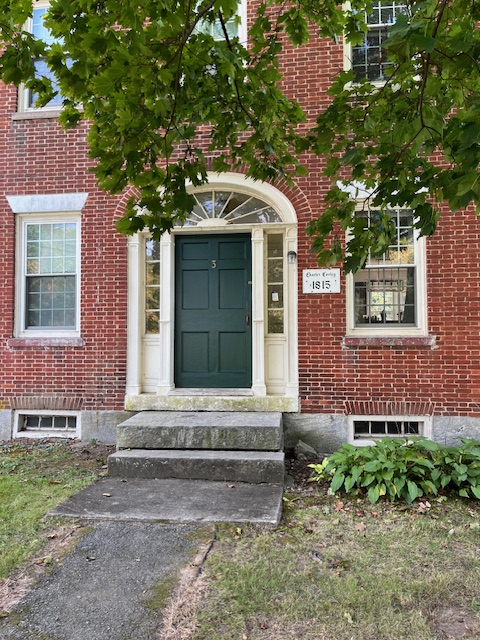
# 1 Plumtrees Road, Sunderland. Photo: Hetty Startup
Amherst History Month by Month
This column is the third in a series of 10 on towns surrounding Amherst. Previous columns covered Pelham and Shutesbury.
Sunderland is a gem of a town that adjoins Amherst where the Franklin and Hampshire county lines meet. It has great views of Mt. Sugarloaf (although this stunning landmark is in South Deerfield), and a beloved roadside cafe called Sugarloaf Frostie. Sunderland extends south from its ancient caves (a part of Mount Toby) in the north, through the neighborhood of Cliffside apartments, other housing developments, Kitchen Garden Farms, ‘down’ (south) to Plumtrees and the town border with North Amherst.
Most of present-day Sunderland was portioned off in 1673 from Hadley with Plumtrees added in the 1730s after a period of intense warfare ((Queen Anne’s War 1702-1713) and the Wabanaki-New England War (aka Gray Lock’s or Dummer’s War) – 1722-1725)).
Sunderland’s western border hugs the Connecticut river (Kwinitekw in Nipmuc) but today – if we just examine one street in town – it is hard to imagine that School Street (once Bridge Street), a little side street running from North Main Street to the shoreline, was the crucial access for most transportation and ferry traffic for the region.
Try thinking back about 200 years to visualize the early 1800s and see a toll house (booth) there (swept away in subsequent ice floes and flooding). People in town then made a living up and down the Kwinitekw River running small businesses, services, or trades that needed a dependable source of water for their survival. Much later, a Sunderland resident named Ben Toczydlowski built a service station/ice cream store on this same street. When a new bridge was built over the river, he moved his business to Bridge St (Rt. 116) in 1938 and then converted the building into a liquor store. It is still in operation, but I am getting ahead of myself.
A major change of use (that today we would call zoning) to School Street came in the late 1800s when it became much more residential, and several homes were built by the shore of the river. A new Bridge Street road – parallel to the current School Street – was added in the 1930s. By then, a Classical Revival style school building graced School Street designed by Karl Putnam in 1922 (now the town offices).
Most recently, School Street has become home to the new public library replacing a smaller but distinguished Tudor Revival-style building, the Graves Memorial Library (1900) that sits on the corner of School Street and North Main Street (the southernmost point of the historic, colonial town center.) And at the shoreline, a fully accessible trail/walk, opened to the public in 2019, takes you to the public boat launch, Riverside Park, and offers views of the South Deerfield – Sunderland bridge (just resurfaced) and of First Island, home to hawks and eagles. It is worth remembering that this mighty body of water has multiple Native names like Quinnehtukqut or Quinetucket (Mohegan) and Kwanutekw (an Abenaki word meaning long river); the word Connecticut takes these different indigenous names creating what is called a “corruption” from the original languages.
This little guided ‘time machine’ exercise may tell us how much Sunderland has changed but also how much folks here have worked to preserve it. There are many helpful resources if we care to learn more, although they are too numerous to fully incorporate into this article. But one resource is always around and available to us (if we take care to preserve it) and that is the way Sunderland as a town looks today, telling us so much in a material sense about New England’s architectural styles.
Today you can walk from Millstone Market (itself a modest, roadside gem) or the historic Warner Farm/Mike’s Maze on South Main Street down to #1, Old Amherst Road and there, view the Benjamin and Thankful Field Graves House built in 1753.
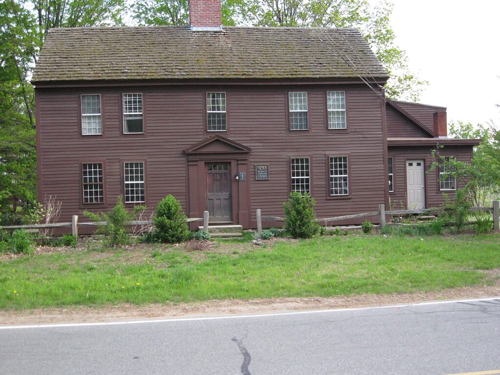
As is typical of the saltbox style – seen in places like nearby Hadley and Historic Deerfield, the home is made of local timber, with a large central, brick chimney. The overall appearance is one of symmetry, a characteristic of this “Georgian” architectural style (named for British kings, George 1, George II and George III) also known as the First Period architectural style (1675-1775). Issac Graves, one of the founding proprietors of Sunderland, apparently built this house and lived here. His descendants lined Main Street with maple trees and their family descendants still live in town and own the Millstone Market. The word “saltbox” tells us about the shape of the house with a roof that extends down at the back to the first story. It is easier to see this in person, but it is also possible to view the angle in this photograph.
By the early 19th century, a person called Erastus Pomeroy lived here, and in the 1830s he “drove the stage”, meaning a coach and a team of horses, from South Hadley to Northfield before the beginning of either rail or trolley systems. Freight – still a sight on the railroads today – was later first transported on flatbed trolley cars to the Massachusetts Central Railroad in Amherst that really helped farmers get their goods to more markets (goodbye to scenes from poems in books like ‘The Ox-Cart Cart Man’ by Donald Hall)
Both North and South Main Street in Sunderland are lined with historic homes that demonstrate many of the different styles of architecture prevalent in New England since before the Revolutionary War all the way up to the post World War II period. But don’t let your guard down for there are other towns around Amherst that show this history, too. What is often harder to see and appreciate on our streets today is the pre-modern history associated with historic plantation settlements. This is evident in Sunderland in the form of its older name, Swampfield, and in the documentation of its earlier indigenous trail systems that existed prior to the First Period/Colonial era in architectural history, in other words before the Graves house was built.
Both Sunderland’s library and historical society are rich seams of information for town history. It turns out that “…massive dislocations and reorganizations of Indigenous communities in the Northeast by the mid-18th century [took place] and …colonial settlement, military aggression, and forced removals broke up the middle Connecticut River Valley’s traditional [Native] communities. Many Indigenous residents, but not all, fled the region, integrating into other safer communities, such as the Schaghticoke settlement in New York, (see here)” which is about 28 miles from North Adams, Massachusetts.
In my Indy Features column, I have addressed the very different understandings that exist today of the word “land” and/or “settlement” in the context of Native histories of both Amherst and this region more generally (see here) to distinguish the making of one kind of history from another. When British royalists established Swampfield/Sunderland as a new ‘plantation’ in 1673-4 [a word that came to be used later mostly to define southern US colonies that were dependent on enslaved labor], “…the settlers… [had] purchased the land, for a token amount, from the Norwottuck[s]. A year later, [the town] had been surveyed, built upon and occupied. [But] shortly thereafter, it was abandoned, when relations with the Native Americans became hostile.” (see here). According to many historians who now study this period, it is more widely known that land transfers then could have been fraudulent or in some way legally problematic. Swampfield’s “plantation” of colonial buildings was imposed on older trail networks and ancient thoroughfares stewarded by generations of Norotuck, Nipmuc/Nipmuk, and other tribes.
Incorporated as the town of Sunderland in 1718, the local historical society still bears the name of Swampfield as does a road in town by the new Elementary School. When the town’s founders (called proprietors) called a minister to settle the first meetinghouse, built around 1717 (now long gone but close to School Street (near the Sunderland Convenience Corner) they were compensated for their labors in pork from pigs raised on the land) and in crops harvested nearby on the Connecticut river. More about that in a moment.
Like the richer communities of nearby Hadley and Hatfield, where the “River Gods” lived, Sunderland farmers began growing broom corn as a cash crop and then settled on tobacco around 1859. Unique barns for this crop start to dot the local landscape by the mid-nineteenth century. By 1830, there were about 666 people living in Sunderland. Most were farmers who began to stall-feed cattle, learning that by rearing cows inside in the long winter months they could feed them up, then take them to market in Brighton to be sold in the spring. Middle Connecticut River settlement farmers also learned trades associated with livestock farming like making butter, tanning and curing animal hides to diversify their businesses. Two places in Sunderland had tanning shops (no, not that kind!) on North Main Street in the mid-1800s. A few farmers made churning butter their specialty, a traditional craft that was mostly done inside the household.
There is a delightful poem by a young Seamus Heaney called “Churning Day” that offers an insight into the miracle that is butter forming from cream in old Northern Irish farmhouses, but the atmosphere might also have been found here:
“Where finally gold flecks
Began to dance. They poured hot water then,
sterilized a birchwood bowl
and little corrugated butter-spades.
Their short stroke quickened, suddenly
a yellow curd was weighting the churned-up white
heavy and rich, coagulated sunlight
that they fished, dripping, in a wide tin strainer,
heaped up like gilded gravel in the bowl.”
By 1825, there was a local bank at 108 North Main St that became a general store in 1832 and is now the Blue Heron restaurant. A Town House – at 104 North Main St – was designed in the Greek Revival architectural style between 1820-1828. Ahead of the Commonwealth, church and state separated in Sunderland and a parish formed with a Congregational church, built in 1830-4.
My other architectural gem comes from an area closer to Amherst. This is #1, Plumtrees Road, a house I have always been fascinated by. [The Plumtrees area was added to the town in 1729 and was settled in 1730.] This is Sunderland’s only brick Federal style house with a hipped roof, a set of interior chimneys on either side, and a central – very fancy – main entry. Window lintels and sills are all made of granite. The main door is framed with a semicircular fanlight (shaped like a fan made of glass) over supporting pilasters (columns that suggest structural weight-bearing but are decorative) and recessed sidelights of small glass panes. This house was built by Charles Cooley in 1815, a great grandson of Simon Cooley who was one of the original Sunderland proprietors. It may have been connected as a property to #3 Plumtrees Road. Similar brick Federal homes are in North Amherst (the Joseph Cowles House known now as the Black Walnut Inn, at 1184, North Pleasant Street, built in 1821) that is attached to a Stick style barn and Historic Deerfield’s earlier Federal home called the Stebbins House (1799) that possibly revealed the hand of the architect Asher Benjamin


By the end of the 1800s, Sunderland was a very diverse town in terms of population. From 1880-1915 many immigrants, recruited from the docks in places like New York, came here to work as farm hands from Austria, Latvia and Lithuania, from Russia, Poland and the Czech Republic (then Czechoslovakia.) Like the Irish, Germans, and French-Canadians before them, everyone came to seek new lives, to work, building the railroads at first. The newer migrants, also from the ‘old world,’ stayed on, often marrying or at the very least, being joined in migration patterns by other family members. Some became landowners and farm owners themselves. One leading citizen in Sunderland was Franklin H. Williams whose diary from 1852-1891 has survived (Franklin H. Williams Diary from 1825-1895, published by the Williams Family of Sunderland in 1975 and available at the Swampfield Historical Society in Sunderland). This amazing document gives more specifics about the life here of an immigrant farmer. He churned butter and grew broad-leaf tobacco, often a bumper crop. As we approach winter, let’s remember that Williams spent his time cutting and harvesting ice from the ponds on the Falls Road, in view of Mount Toby and continued cutting wood there.
There is a walking tour with a map of buildings on Main Street that is keyed to descriptions and images in this article.
1+2+4+7+14=28
By canoe, we find School Street,
By bike, the Buttonball Tree,
And by reading The Indy,
Stephen and Hetty: compleat!
In case the editor finds this poem a bit too obscure, here are references for the title
https://mathworld.wolfram.com/PerfectNumber.html
and for what is one of the largest sycamores in the world, about which the other-mentioned writer has written about earlier in The Indy.
https://en.wikipedia.org/wiki/Buttonball_Tree
Thanks for adding your ‘math’ poem, Rob!
The famous Buttonball/sycamore tree (on North Main St) reminds me of an article in the DHG (02-14-2019, A land once under water) about the work of UMass professor, Julie Brigham-Grette that digs deeper into the pre-history of this area. In it, she re-tells the Pocumtuc story about Ktsi Amiskw, an ancient beaver who “hoarded all the area’s waters to himself in a great pond” (Lake Hitchcock), thereby angering the giant spirit known as Hobomok who broke the beaver’s back and turned them into Mount Sugarloaf. I first heard this story from Sarah Pirtle who had heard it from Marge Bruchac. More here: https://en.wikipedia.org/wiki/Sugarloaf_Mountain_(Massachusetts)
Tim Wilcox – founder, with Caroline Pam – of Kitchen Garden Farm – also just told me that Erastus Salisbury Field, the 19th American artist, lived at Plumtrees. More here: https://en.wikipedia.org/wiki/Erastus_Salisbury_Field
The history of this area is alive in countless ways not just in historic architecture but also in the land itself – and what we collectively know, learn, and re-learn about it.
For information on the origin of the name of the town of Sunderland and other towns in this series, see the wonderful, detailed podcasts about Western Mass History https://podcasts.apple.com/us/podcast/western-mass-history/id1632995122